Windward to Leeward Training
PN022026
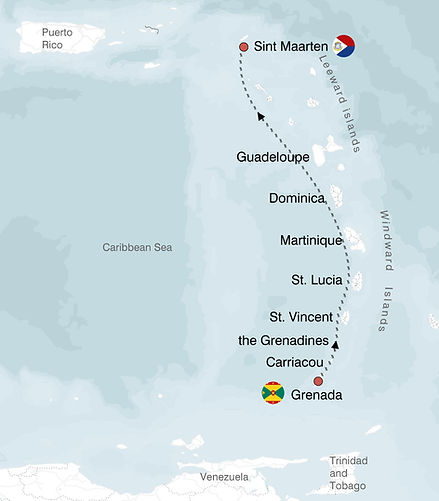
Grenada to St Martin
Jan 31st to February 7th 2026
Duration 7 Days
500 Nautical Miles
WAITLIST
$4,800
This passage provides a classic northbound Caribbean training opportunity, traveling from Grenada to Sint Maarten with multiple potential island stops along the way. The focus is on continuous offshore and inter-island experiences, active night watches, and exposure to a range of navigational and weather scenarios as we move up the Windward and Leeward island chains to Sint Maarten. Routing and specific stops will be adjusted based on real-time weather, sea state, and crew input. Any of Libra's North and South passages through the Caribbean are a great intro to either bringing your own boat, or chartering. You get to experience the entire easter Caribbean conditions in one passage.
Passage summary
Route Overview
Primary Route (and possible stops):
Grenada – Carriacou & the Grenadines – St. Lucia – Martinique – Dominica – Les Saintes – Deshaies (Guadeloupe) – Sint Maarten
Estimated Distance:
475–500 nautical miles, depending on stops and routing
-
- Key Points: Coastal and offshore navigation north along the island chain, multiple overnight passages, variable stops at anchorages depending on timing and weather.
Passage Breakdown
Grenada to Carriacou & the Grenadines
-
-
Crew briefing, vessel checks, and weather review in Grenada before departure
-
First leg to Carriacou and through the Grenadines, with anchoring opportunities at Union Island, Mayreau, or Bequia based on timing
-
Watch rotation (3 hours on, 6 hours off) established immediately, all crew involved in navigation, log keeping, and sail handling
-
Up the Island Chain (Windwards & Leewards)
-
-
Successive offshore legs north along the Windwards and into the Leeward Islands
-
Potential anchorages or brief stops:
– St. Lucia
– Martinique
– Dominica
– Les Saintes (Guadeloupe)
– Deshaies (Guadeloupe) -
Multiple overnight sails required to cover distance and manage weather windows
-
Navigation includes coastal piloting by day and open-water passages by night
-
Final Approach to Sint Maarten
-
Final overnight passage north to Sint Maarten, with arrival and customs check-in at the marina
-
Crew dinner ashore at Lagoonies Bistro
Training Focus
-
Offshore and inter-island passage planning: route selection, waypoints, and safe harbor identification
-
Practical navigation: use of chartplotter, radar, AIS, GPS, and visual references
-
Watchkeeping: helm, lookout, sail management, log entries, and system checks
-
Night operations: navigation, safety, lighting protocols, and fatigue management
-
Sail management: headsail changes, reefing, downwind and reaching techniques for variable trade wind angles
-
Real-time weather assessment and route adjustments based on forecasts and conditions
Expected Conditions
Winds: E–ESE trades, typically 15–25 knots in open water; possible gusts in squalls and acceleration zones between islands
Seas: 4–8 feet in open channels, moderate to rough at times, with shorter-period chop between the islands
Weather: Mostly clear with trade wind cumulus, brief squalls possible especially near island channels, warm and humid throughout
Hazards: Traffic in coastal approaches, occasional fishing gear, squall lines, and strong currents between certain islands
Why This Passage is Relevant
-
Combines continuous offshore sailing with multiple island landfalls
-
Requires active night watches and real passage-making skills
-
Broad exposure to navigation scenarios: open water, coastal, and inter-island
-
Ideal for sailors seeking multi-day watch experience and mile-building under realistic conditions
- You get to experience the entire easter Caribbean conditions in one passage
